and Chasing
[Index][Archives]
Observing a trough of low pressure on the ground
by Jimmy Deguara
| Storm News and Chasing [Index][Archives] |
Observing a trough of low pressure on the ground by Jimmy Deguara |
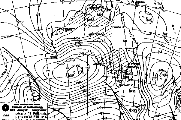
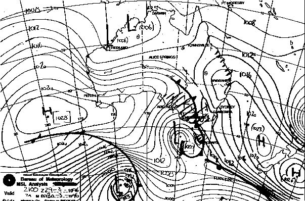
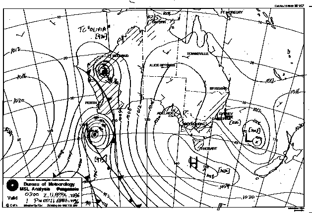
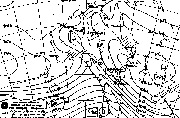
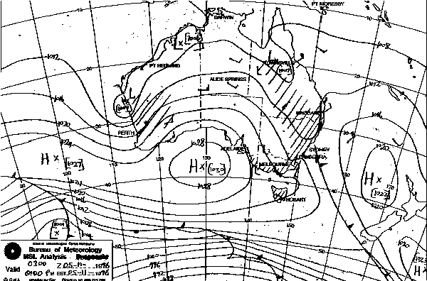
A trough of low pressure is merely an extended region of low pressure. Presented at left are some examples of different trough situations that can exist. From top: northward extending trough; prefrontal trough; coastal trough; trough line; and trough in northern NSW.
Troughs of low pressure are important because they sometimes lead to the development of a low pressure system. In such a process, the developing cloud mass associated with a trough often originate from thunderstorms which then may further develop into rain events. The lack of heating due to widespread cloud then decreases the likelihood of organised thunderstorm activity with the development of a low, although storms still can occur in some cases.
Troughs of low pressure are responsible for the most severe thunderstorms. The best situation is the trough line where there is a separation of dry air and moist air mostly along a line. The best storms occur when moist air is isolated in a region of dry air.
There are several situations that can exist. It depend on the experience of the person observing the weather as to how successful a trough can be detected. There is no one method to use but a "combination" of the following factors or observations can be considered.
In most cases, cirrostratus (high cloud) develops. Sometimes, altostratus and altocumulus (middle level clouds) also develop and follows the high cloud. If high cloud develops from the north-west or north, this almost certainly is a trough as most high level and even middle level clouds approach from the west or southwest with a cold front.
If altocumulus seems to be heading east, and cirrostratus moving southeast, you may find that the altocumulus is developing at the rear. The cloud seems to never clear despite moving east. This also means that a trough may be active.
You may find altocumulus moving south-east and increasing in development. This can happen particularly after overnight thunderstorms have cleared to the east or south-east. Thunderstorms will re-develop during the day unless the trough begins to clear. The trough is already active.
In clear weather, the first signs of a trough developing are increasing temperatures and cumulus beginning to develop, becoming progressively larger as well as more frequent over a few day period. Again, high cloud develops before or with the cumulus.
Winds are normally light from the ocean or from the north. The wind strength may increase but generally from the north or north-east.
Another characteristic of a trough is the moisture haze. Sometimes, there is a progressive decrease in the visibility over a few day period.
Increases in moisture will also be noticed with trough development.
In NSW, troughs often develop along the northern inland due to the effect of onshore winds passing over the mountains. In this case, regions to the south may observe progressive cumulus development further south over a few day period. Again, you may observe larger cumulus or thunderstorms to the north since this is where it originates. These thunderstorms may persist with an increasing southward trend in development. In other words, more active storms may develop further south as the trough extends south.
If a trough is extending north from a low pressure system to the south, the same conditions are likely but cloud will progress and develop towards the north over a few day period. Thunderstorms or thundery showers are more likely to develop towards the south. Middle level cloud can approach from various directions in this case and so can cirrostratus. Thunderstorms or thundery showers may also begin to develop in this period. They may become increasingly widespread.
In cloudy conditions, cloud may be forecast to clear after a change has produced shower activity along the coast. If this cloud (stratocumulus or low cloud) persists over a few day period, a trough may be developing. In particular, the cloud begins to resemble a middle level cloud: stratocumulus become more like altocumulus in appearance. Or it may form into a more cumulus structure.
Sometimes, persistent cloud situations may reveal high clouds through breaks in the lower cloud and you follow the rules above. The stratocumulus or low clouds may or may not clear as the trough becomes active. Try and determine which way the high cloud is moving.
The most exciting type of trough as mentioned above is the trough line. This is easier to recognise after it has passed than when it is approaching. But, that then becomes useless to predict thunderstorm activity. Remember, a trough line is a boundary where drier air meets warm moist air. So ahead of a trough line will be increasing cumulus congestus (clumps of large billowing cumulus growing rapidly) and especially altocumulus castellanus (altocumulus with cumulus tops). A persistent trough line will continuously produce thunderstorms, some may be severe. Therefore, it is not so unusual to have altocumulus castellanus appearing during the morning and developing. If the altocumulus castellanus is developing just to the north, then it has already passed through. If cumulus and altocumulus castellanus continue to develop to the west and move east, the trough line is located to the west and you may receive thunderstorms later. Cirrostratus will also be observed indicating how the trough line may progress.
Moisture haze also can be an indicator. It is more hazy in the region of thunderstorm development and clear and dry on the other side of the boundary. If the trough line is moving through, the heights of the cumulus will decrease and not develop into thunderstorms and a change in visibility will also be noticed along this boundary. The hazy region will have thunderstorms developing side by side. Trough lines mostly are aligned north to south or north-west to south-east.
These are some of the most common indicators of trough development. The best way to learn how to utilise these rules is to practice them through trial and error in your observations. You will eventually get the hang of it.
The observations described are valid for Sydney and surrounding areas, and may also be useful for most parts of central eastern Australia.
I would welcome observations of troughs from other parts of Australia.
from the Bureau of Meteorology
|
Document: 9607-01.htm
Updated: 6th April, 2004 |
[Australian Severe Weather index] [Copyright Notice] [Email Contacts] [Search This Site] |