and Chasing
[Index][Archives]
Snow Chase: Thursday 27th July 2000
by Andrew Godsman
| Storm News and Chasing [Index][Archives] |
Snow Chase: Thursday 27th July 2000 by Andrew Godsman |
Firstly it was
down to Saddleback Mt, just south of Kiama in the Illawarra, and it was obvious
that the change was on the way up the coast. On the way to Kiama there was some
good cb's showing in front of the main cloudbank. 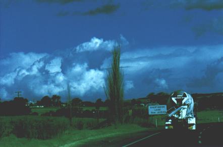 After I got to the lookout at around 2:40pm, the view south was okay, plenty of
cu, but the cloudbank seemed to be slow moving. Interestingly, there seemed to
be some snowy/showery looking clouds travelling over the escarpment west of Nowra,
from a SSE'ly direction. I decided that there might still be a chance of snow
after all so headed down through Jamberoo, up Jamberoo pass and on to Robertson.
After I got to the lookout at around 2:40pm, the view south was okay, plenty of
cu, but the cloudbank seemed to be slow moving. Interestingly, there seemed to
be some snowy/showery looking clouds travelling over the escarpment west of Nowra,
from a SSE'ly direction. I decided that there might still be a chance of snow
after all so headed down through Jamberoo, up Jamberoo pass and on to Robertson.
Arriving at Robertson, and taking a couple of snaps along the way, things were looking decidedly better to my south. I stopped to grab a pie from the Robo pie shop and drove just west and sat back to wait for the front. I called Jimmy Deguara also to see what was happening and to report some nice frontal features with the hint of snow on the way. After a short while the guster took shape with the steep valleys south contributing plenty of scud to make it look great, but it seemed to be slipping SE, so I drove back to a point east of Robo and sat back.
It didn't take
long, around 3:55 the front passed over and as I stood outside the first shower
of around 2-3mm hail fell. 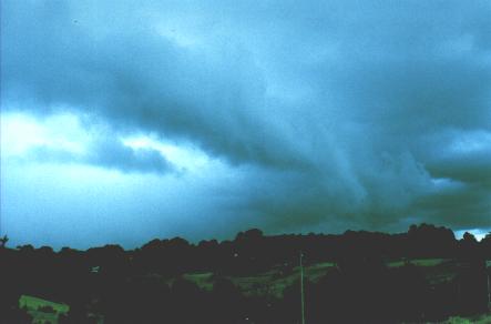 The temperature dropped to what felt like freezing instantly, and the next shower
started as mushy rain, then large snow flakes fell, mixed with periods of light
slush. About this point things start to get hazy as the full grip of chase fever
took over. After a short while it seemed to be settling back to mostly rain so
I decided to head for the higher ground again.
The temperature dropped to what felt like freezing instantly, and the next shower
started as mushy rain, then large snow flakes fell, mixed with periods of light
slush. About this point things start to get hazy as the full grip of chase fever
took over. After a short while it seemed to be settling back to mostly rain so
I decided to head for the higher ground again.
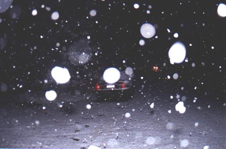
When I arrived, there appeared to be snow on the ground, but instead it was drifts of hail, mostly 2-3mm, but a few getting up to 5-7mm. As I waited the first heavy snow shower moved in. The next twenty minutes up to 4:45pm saw snow mixed with light showers, which I again reported to Jimmy, before the gods answered my calls and suddenly everything went white. Within twenty minutes the ground was white, my car (very dark grey) was white, and the flakes were getting bigger and bigger. Also, my film was getting lower and lower as I hooted and hollered as things went progressively whiter and whiter.
Around 5:10 I drove back to Robertson and picked up more film, then headed back to the same spot. Snow was falling heavily in the township. Extremely heavy snow then continued to fall until about 5:40 by which time a good 3-4cm had settled on the ground.
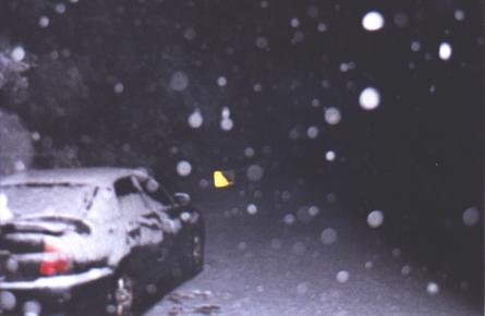
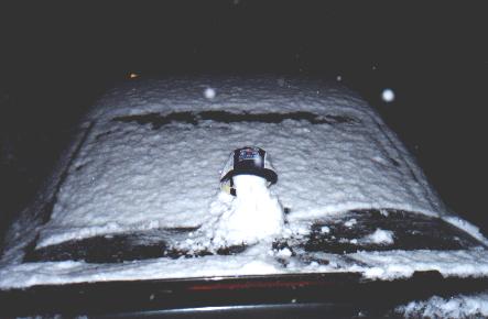
The snow was completely dry, large flakes, which compacted greatly when I made a snowman on the back of my now white car. The road was also covered in about 3-4cm, even where traffic was going over. So with it easing up to light snow, getting dark and me getting worried about being able to get out if the roads got much worse I headed back down Macquarie Pass to Wollongong. Snow had settled all the way to the top of the pass. I arrived home at 6:30, dry warm and with a buzz that'll carry me through for a while yet.
|
Document: 0007-03.html
Updated: 2nd November, 2001 |
[Australian Severe Weather index] [Copyright Notice] [Email Contacts] [Search This Site] |