and Chasing
[Index][Archives]
Coffs Harbour Flash Flood: Saturday 23rd November 1996
by Michael Bath
| Storm News and Chasing [Index][Archives] |
Coffs Harbour Flash Flood: Saturday 23rd November 1996 by Michael Bath |
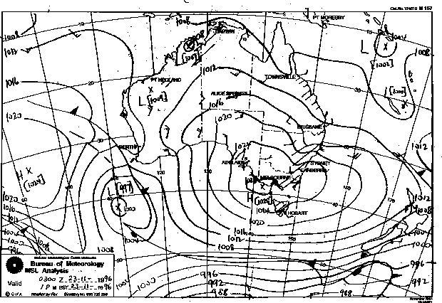
The region of cold upper air moved north-northeast clearing the cloud and rain from southern coastal parts of NSW. However, a small surface low developed off the NSW coast in an already established easterly stream (a high centred over Bass Straight) and combined with the upper low to drag huge quantities of moisture off the ocean. The wind flow converged on the Mid North Coast town of Coffs Harbour, and resulted in torrential rain in the area.
Up to 300mm of rain in 2 hours fell, however official Coffs Harbour rainfall readings were 93mm and 168mm for 24 hours to 9am 23/11 and 24/11 respectively. A flash flood raged through Coffs creek early Saturday evening, inundating over 300 homes and businesses with up to a metre a water, which was made worse by the water backing up due to high tides.
A women was swept to her death from a caravan park adjacent to Coffs creek.
Damage is expected to run into tens of millions of dollars, and a natural disaster declared.
Some rainfall figures from Don White
The maximum rainfall from this event was at South Boambee AWS - a mountain pluvio set up by BoM and Manly Hydralics. It measured 493 mm in the 24 hours to 9 am on 24/11/1996
Max intensities were:
64.5 mm in 30 minutes at 8.10 pm on 23rd
111.5 mm in 1 hour from 7.55 pm
198.0 mm in 2 hours from 7 pm
272.5 mm in 3 hours from 6 pm
335.0 mm in 4 hours from 5 pm
399.5 mm in 5 hours from 4 pm
446.5 mm in 6 hours from 3 pm
488.5 mm in 12 hours from 9.15 am
Other AWS's in the area reported a little less:
Newports Creek 274 mm in 4 hours and 365 mm in 6 hours.
Middle Boambee 256 mm in 4 hours and 357 mm in 6 hours
North Bonville 287 mm in 4 hours and 375 mm in 6 hours
Based of probability plot of past data, the 3 hour fall has a retrun period of 1 in 4000 years !!!
The 4 hour total broke the previous NSW record of 290 mm at Federal near Lismore on 29 Feb 1976 but the 6 hour fall fell short of the 515 mm at Wongawilli SW of Wollongong on 18 Feb 1984. Note that Binbee (Qld) had 607 mm in 4.5 hours on 6 Jan 1980 while the world record still stands a 782 mm in 4.5 hours at Smethport, USA on 18 July 1942
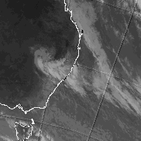
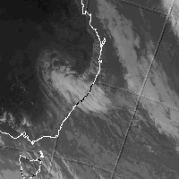
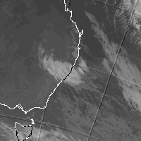
These images obtained from the Bureau of Meteorology
|
Document: 9611-02.htm
Updated: 6th April, 2004 |
[Australian Severe Weather index] [Copyright Notice] [Email Contacts] [Search This Site] |